
'Tornado' hits village in Midlands as 55mph winds batter parts of UK

A village in the Midlands appeared to be hit by a tornado as strong winds battered almost all of the UK on Monday, with some gusts expected to reach up to 55mph.
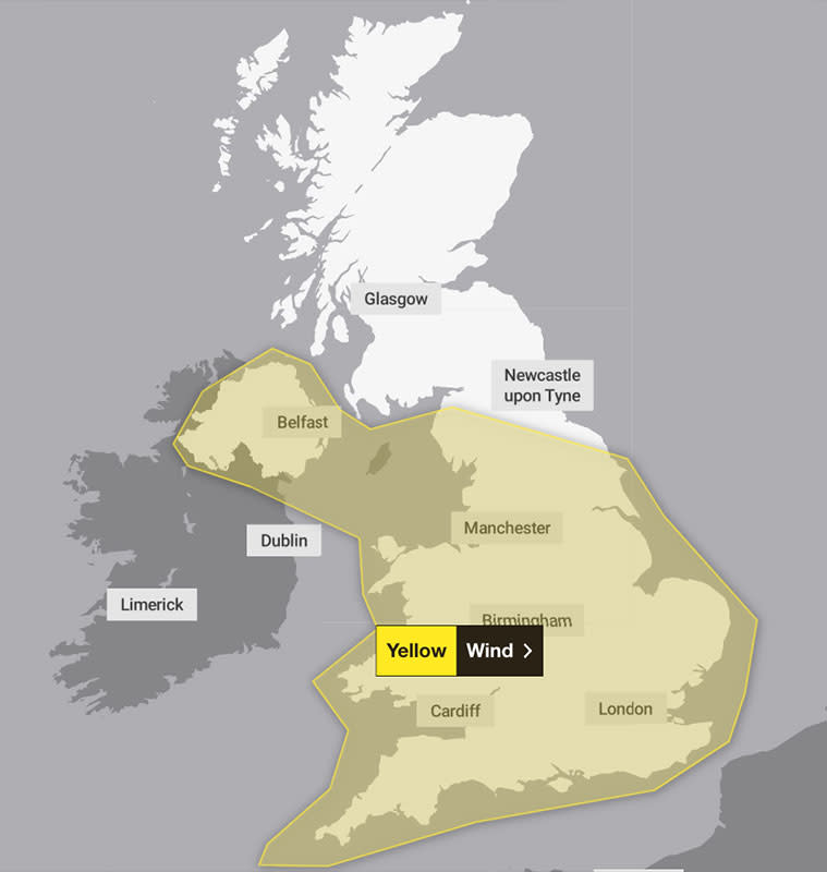
The Met Office has issued a yellow weather warning for wind for the whole of Northern Ireland, the whole of Wales and most of England.
The warning is in place until 10pm and could see wind speeds as high as 55mph in some coastal areas, while heavy showers are also forecast.
It includes the village of Knutton, in Newcastle-under-Lyme, Staffordshire, where pictures shared on social media showed damaged roofs and fences, and debris scattered across the street.
Watch: 'Mini-tornado' causes chaos in Staffordshire town
While the Met Office said it wasn't possible to verify if a tornado had hit the town, the forecasting body said Monday's strong winds “had some potential” to create them.
“Tornadoes do happen in the UK and they’re generally short-lived in nature, but around 30 a year are reported on average," Met Office spokesperson Stephen Dixon added.
The Met Office's yellow warning means delays to road, rail, air and ferry travel are "likely", the Met Office said, and that short-term power cuts are "possible". Kew Gardens in south west London announced it would be closed on Monday because of the high winds
The Met Office said a depression system will bring a "swathe of strong winds to Northern Ireland, Wales and much of England".
Those winds are expected to reach speeds of up to 45mph inland and 55mph on exposed costs, the Met Office said, with northern Wales and Scotland forecast to see some sleet and hail.
The unsettled weather is expected to clear after Monday and leave the rest of the week with mostly dry conditions.
“Monday is classic April showers really," said Met Office forecaster Simon Partridge. “We’ve got a pretty windy day across the whole of the UK with gusts of wind up to 40-50mph pretty much anywhere across the country.
⚠️ Yellow weather warning issued ⚠️
Wind across parts of England, Wales and Northern Ireland
Valid until 22:00 Monday 15th April 2024
Latest info 👉 https://t.co/QwDLMfRBfspic.twitter.com/gHIKOKkfeT— Met Office (@metoffice) April 15, 2024
“With that, we’ll have some quite blustery showers which will be slightly wintry in nature across the northern parts of the UK. You could get a little bit of sleet and certainly some hail so it will be a much colder feeling day.”
The wet weather follows a warm weekend in which the highest temperature of 21.8C was recorded in Writtle, Essex, on Saturday.
Read more: Pictures show Storm Kathleen flood chaos as holiday park evacuated (Yahoo News UK)
Yahoo breaks down what the weather will be like for each region of the UK, according to the Met Office.
London and the South East
Monday and Tuesday
A band of heavy and blustery showers will move southeast across the region this morning, clearing to an afternoon of bright spells and scattered showers. Maximum temperature 12°C.
Showers will ease during the evening with drier conditions gradually spreading across the region from the northwest. Remaining breezy.
Cool and cloudy start on Tuesday with any early showers in the far southeast soon clearing. Brightening up from the west to sunny spells and a few showers. Maximum temperature 13°C.
Wednesday to Friday
Remaining changeable Wednesday with scattered showers. Largely cloudy and dry Thursday. Outbreaks of rain and drizzle overnight and Friday morning, then brighter. Temperatures turning a little milder Thursday.

South West
Monday and Tuesday
Sunny spells and blustery showers, possibly heavy at times with hail, especially through the morning, though becoming more scattered by the afternoon. Feeling noticeably chiller compared with recent days particularly in the brisk winds. Maximum temperature 12°C.
Showers easing overnight and becoming largely dry though staying fairly windy overnight and feeling chilly still in the brisk winds.
A drier day on Tuesday with sunny spells, though the odd shower still possible. Another breezy day though winds much lighter than Monday. Feeling fresher than of late. Maximum temperature 13°C.
Wednesday to Friday
Generally dry for the rest of the week though cloudy at times with some showers possible. Temperatures around the seasonal average and a noticeable fresher feel to the weather.
Midlands
Monday and Tuesday
Sunny spells and scattered blustery showers, these heavy at times with hail, particularly during the early hours of the morning where showers may turn squally. Feeling noticeably chiller compared with recent days. Maximum temperature 10°C.
Showers easing overnight into Tuesday and becoming largely dry though staying fairly windy overnight and feeling chilly still in the brisk winds. Minimum temperature 5°C.
Wednesday to Friday
Generally dry for the rest of the week though cloudy at times with some showers possible. Temperatures around the seasonal average and a noticeable fresher feel to the weather.
North East
Monday and Tuesday
A day of showers interspersed with some bright spells. Showers turning heavy at times with the odd rumble of thunder and a risk of hail. Feeling cold, especially in the strong winds. Maximum temperature 9°C.
Showers will gradually fade through the evening becoming largely dry inland overnight, although showers are expected to continue to affect coastal areas. Remaining windy overnight.
A bright and breezy Tuesday after a chilly start. Scattered showers are likely to break out Tuesday afternoon with a band of more organised showers expected later and overnight. Maximum temperature 10°C.
Wednesday to Friday
Rather cold and breezy Wednesday with occasional showers. Largely cloudy Thursday and Friday with outbreaks of rain and drizzle. Temperatures recovering to near normal. Winds easing.

North West
Monday and Tuesday
Sunny spells and blustery showers, possibly heavy at times with hail, the odd rumble of thunder and some wintriness over the hills. Feeling noticeably chiller compared with recent days. Maximum temperature 9°C.
A drier day on Tuesday with sunny spells, though the odd shower still possible. Another breezy day though winds much lighter than Monday. Feeling fresher than of late. Maximum temperature 10°C.
Wednesday to Friday
Generally dry for the rest of the week though cloudy at times with some showers possible. Temperatures around the seasonal average and a noticeable fresher feel to the weather.
Scotland
Monday and Tuesday
A mixture of bright spells and showers, the showers heavy at times and wintry over the hills. Chilly west or northwest winds. Maximum temperature 10°C.
Remaining showery tonight, these heaviest and most widespread this evening and wintry at times over the hills. Occasional drier and clearer spells overnight.
Another day of bright spells and showers on Tuesday. A few sunny breaks possible, but feeling chilly in the brisk northwest winds. Maximum temperature 10°C.
Wednesday to Friday
Rather cloudy with occasional rain or showers, although a mainly dry and bright start on Wednesday. Turning drier on Friday. Breezy at times.

Northern Ireland
Monday and Tuesday
It will be a showery day, these heavy and frequent at times and wintry over the hills. Feeling chilly in the strong west or northwest winds, gales around the coast. Maximum temperature 9°C.
Remaining showery tonight, these heaviest and most widespread this evening. Some drier and clearer spells overnight.
A mixture of bright spells and occasional showers on Tuesday. A few sunny spells, the best of these early and later in the day. Chilly northwest winds. Maximum temperature 11°C.
Wednesday to Friday
Rather cloudy with occasional rain or showers, although a mainly dry and bright start on Wednesday. Turning drier later on Friday. Breezy at times.
Wales
Monday and Tuesday
Sunny spells and blustery showers, possibly heavy at times with hail, the odd rumble of thunder and some wintriness over the hills. Feeling noticeably chiller compared with recent days. Maximum temperature 11°C.
Showers easing overnight and becoming largely dry though staying fairly windy overnight and feeling chilly still in the brisk winds.
A drier day with sunny spells on Tuesday, though the odd shower still possible. Another breezy day though winds much lighter than Monday. Feeling fresher than of late. Maximum temperature 13°C.
Wednesday to Friday
Generally dry for the rest of the week though cloudy at times with some showers possible. Temperatures around the seasonal average and a noticeable fresher feel to the weather.

