
Giant Antarctic lake ‘suddenly disappears’, leaving four-square-mile crater
A huge icy lake on an Antarctic ice shelf "suddenly disappeared", meaning up to 26 billion cubic feet of water drained into the ocean.
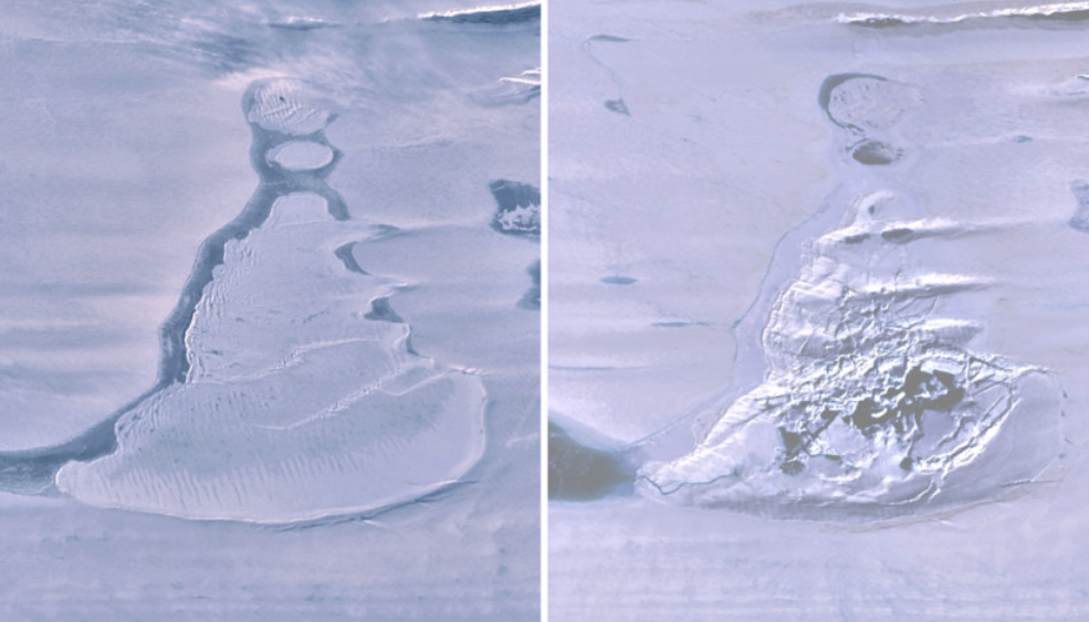
The event, which left a crater up to four square miles in area, happened during the 2019 Antarctic winter on Amery Ice Shelf in East Antarctica.
Researchers from the Scripps Institution of Oceanography at the University of California San Diego believe it could have important implications for global warming projections – and the possible collapse of ice shelves.
The researchers analysed the "disappearing lake" using images from a radar satellite that can "see" during the polar night.
Read more: Melting snow in Himalayas drives growth of green sea slime visible from space
The researchers say that once the water had drained, it left a crater-like depression in the ice shelf surface, known as a "doline", covering about 4.25 square miles.
Lead author Roland Warner, a glaciologist with the Australian Antarctic Program Partnership at the University of Tasmania, said: “We believe the weight of water accumulated in this deep lake opened a fissure in the ice shelf beneath the lake, a process known as hydrofracture, causing the water to drain away to the ocean below."
The hydrofracture process has been implicated in the collapse of smaller ice shelves in the Antarctic Peninsula, where meltwater forms on the surface of ice shelves during austral summer, but it is not often seen driving through ice as thick as the 4,590 feet at this location on Amery Ice Shelf.
The event was also captured by a green-light laser instrument on Nasa’s ICESat-2.
This satellite transmits pulses of photons and accurately locates the reflection point of each photon it receives back from Earth – allowing it to measure land "sinking" and "rising".
Repeat orbits of ICESat-2 on the exact ground tracks before and after the lake drainage revealed the vertical scale of the disruption.
The ice surface fell as much as 260 feet in the doline cavity, even though the loss of the water load made the floating ice shelf lighter, with the lake’s immediate surroundings rising as much as 118 feet.
Read more: A 1988 warning about climate change was mostly right
Co-author Helen Amanda Fricker, a glaciologist at Scripps Institution of Oceanography, said: “It is exciting to see ICESat-2 show us details of processes that are occurring on the ice sheet at such fine spatial scale.
“Since surface meltwater on ice shelves can cause their collapse which ultimately leads to sea-level rise when grounded ice is no longer held back, it’s important to understand the processes that weaken ice shelves.”
In recent decades with rising air temperatures, some ice shelves have experienced greater surface melting, and the most recent model projections for future warming show that trend continuing and creating more melt lakes.
Read more: Why economists worry that reversing climate change is hopeless
This increases the risk of widespread hydrofracturing, which could lead to ice shelves collapsing, permitting faster discharge of ice from grounded ice sheets and increases in sea level.
Possible increased flows into deep, ice-covered lakes and hydrofracture of thick ice shelves should also be considered in projections for future warming, said researchers.
Watch: Can seaweed save the climate?

