
Hurricane heading for Texas and Louisiana upgraded to ‘catastrophic’ Category 4
Forecasters say Laura will intensify into a "catastrophic" Category 4 hurricane – an even stronger storm than previously expected – as it heads towards Texas and Louisiana.
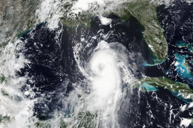
Satellite images show that Laura has become "a formidable hurricane" in recent hours, threatening to smash homes and sink entire communities.
It has undergone a remarkable intensification, "and there are no signs it will stop soon, with shear remaining low-to-moderate over the deep warm waters of the central Gulf of Mexico," the National Hurricane Centre said in a briefing early on Wednesday.
Laura's maximum sustained winds have increased to near 110mph with higher gusts, forecasters said.
"We are expecting widespread power outages, trees down. Homes and businesses will be damaged," said Donald Jones, a National Weather Service meteorologist in Lake Charles, Louisiana, which is near the centre of Laura's forecast track.
"I'm telling you, this is going to be a very serious situation," Mr Jones said.
The National Hurricane Centre said a Category 4 hurricane will cause catastrophic damage that will make the affected areas uninhabitable for weeks or months.
Hurricane #Laura Advisory 26: Laura Expected to Rapidly Strengthen to a Category 4 Hurricane. Forecast to Produce a Life-Threatening Storm Surge, Extreme Winds, and Flash Flooding Over Eastern Texas and Louisiana Later Today. https://t.co/VqHn0u1vgc
— National Hurricane Center (@NHC_Atlantic) August 26, 2020
In the largest US evacuation of the coronavirus pandemic, more than half a million people were ordered to flee from an area of the Gulf Coast along the Texas-Louisiana state line.
More than 385,000 residents were told to flee the Texas cities of Beaumont, Galveston and Port Arthur, and another 200,000 were ordered to leave low-lying Calcasieu Parish in south-western Louisiana, where forecasters said as much as 13 feet of storm surge topped by waves could submerge whole communities.
The situation could be even worse in Cameron Parish, which could soon be under water.
"Cameron parish is going to be part of the Gulf of Mexico for a couple of days based on this forecast track," Mr Jones said.
In Galveston and Port Arthur, Texas, mandatory evacuation orders went into effect shortly before daybreak on Tuesday. "If you decide to stay, you're staying on your own," Port Arthur mayor Thurman Bartie said.
Forecasters expect the storm to increase to 120mph before landfall and push ocean water onto land along more than 450 miles of coast from Texas to Mississippi. Hurricane warnings were issued from San Luis Pass, Texas, to Intracoastal City, Louisiana, and storm surge warnings from the Port Arthur, Texas, flood protection system to the mouth of the Mississippi River.

Fearing that people would not evacuate in time, Louisiana governor John Bel Edwards said those in south-west Louisiana need to reach wherever they intend to ride out the storm by noon on Wednesday, when the state will start feeling the storm's effects.
Officials urged people to stay with relatives or in hotel rooms to avoid spreading Covid-19. Buses were stocked with protective equipment and disinfectant, and they would carry fewer passengers to keep people apart, Texas officials said.

