
Britain braced for heavy snow amid warning of 'nasty' travel conditions

Britain has seen one of the coldest nights of the year as parts of the country brace for heavy snow and strong winds of up to 70mph on Friday.
The mercury plummeted to minus 12.3C (9.8F) at Loch Glascarnoch in the Scottish Highlands overnight while most parts of the UK dipped below freezing, leaving widespread ice a potential hazard as the country gets moving.
Forecasters have warned of disruption to travel and potential power outages as the day progresses as a band of "severe" weather moves in from the east.
With some severe weather on the way, travel could be tricky today. Read our tips for driving in #snow and #icehttps://t.co/uAfqk2MetBpic.twitter.com/71x9iiJMf6
-- Met Office (@metoffice) December 29, 2017
Parts of northern England are on standby for heavy snow on Friday morning, while swathes of the country have been warned of a risk of ice and wintry showers.
An amber warning of snow in West Yorkshire, the South Pennines and places such as Rochdale and Burnley is in place until 11am and a wider yellow warning for snow has been issued for southern and eastern Scotland, northern England and the Midlands until 3pm.
The heaviest snowfall of 5cm-10cm in expected in parts of northern England and up to 15cm over higher ground.
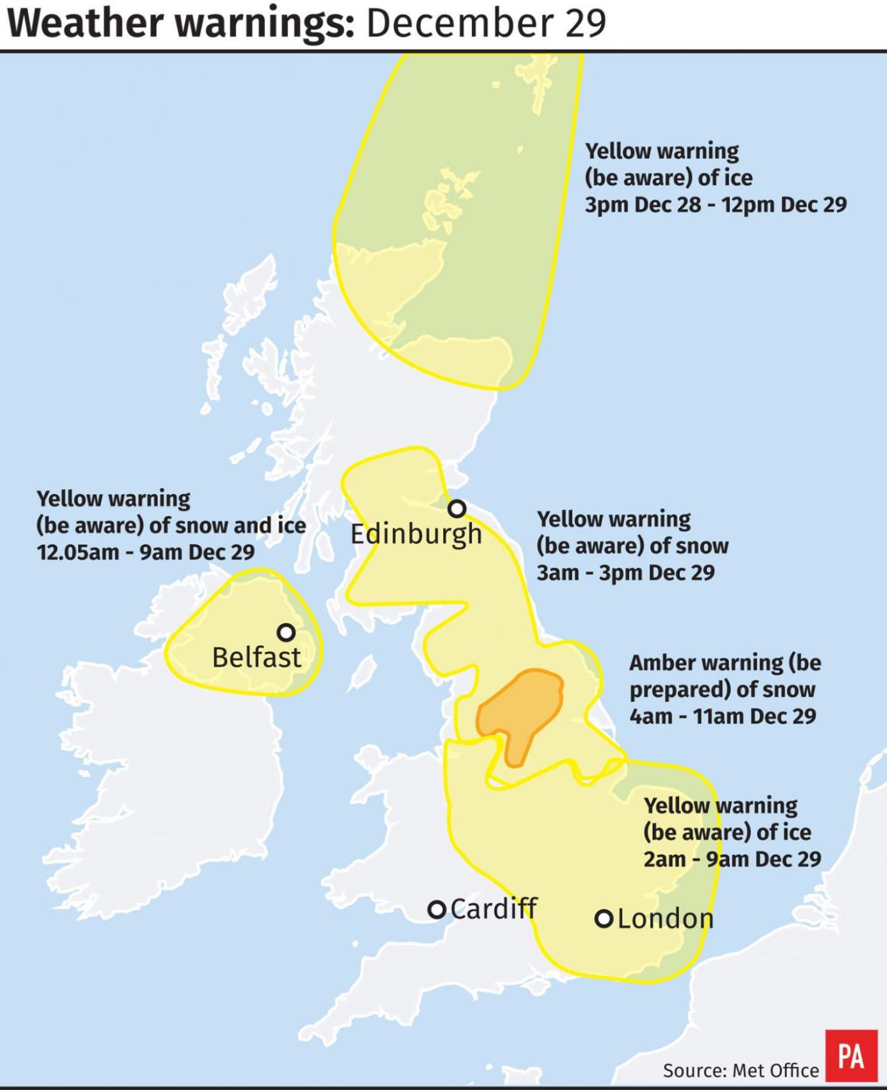
Meanwhile there are yellow warnings for ice across London and the South East, the Midlands and parts of Wales and the North West of England, as well as for the far north of Scotland including Orkney and Shetland.
And a yellow warning has been issued for strong winds expected over parts of south-west England and southern Wales across to Greater London, bringing "potent, heavy showers with a chance of hail and thunder" as the system moves eastwards.
"Gusts of 45 to 50 mph are likely quite widely in and near these showers, with 60mph gusts in places and close to 70mph at times in the most exposed coastal locations," the Met Office said.
Met Office forecaster Charles Powell said there could be some "pretty nasty travel conditions".
"It is a band of severe weather. Weather warnings are in force. There is going to be disruption in some shape or form," he said.
-- Met Office (@metoffice) December 28, 2017
Highways England has issued a severe weather warning and urged people to plan their journeys, monitor weather reports and pack a snow kit of blankets, food, water and a shovel if they really need to travel.
The RAC said it expects to attend "in the region of one breakdown every 10 seconds through the course of Friday".
The organisation's traffic spokesman Rod Dennis said: "Some northern regions are set to see further snowfall in the early hours, making driving conditions very difficult if not impossible where the heaviest snowfall occurs.
"Drivers in the areas likely to be affected should consider delaying their journeys if they are not absolutely essential, as some disruption is likely
(function(i,s,o,g,r,a,m){i['GoogleAnalyticsObject']=r;i[r]=i[r]function(){(i[r].q=i[r].q[]).push(arguments)},i[r].l=1*new Date();a=s.createElement(o),m=s.getElementsByTagName(o)[0];a.async=1;a.src=g;m.parentNode.insertBefore(a,m)})(window,document,'script','//www.google-analytics.com/analytics.js','ga');ga('create', 'UA-72310761-1', 'auto', {'name': 'pacontentapi'});ga('pacontentapi.set', 'referrer', location.origin);ga('pacontentapi.set', 'dimension1', 'By PA Reporters');ga('pacontentapi.set', 'dimension2', '5f7ed486-f565-40c5-a001-ac41461e633b');ga('pacontentapi.set', 'dimension3', 'paservice:news,paservice:news:uk');ga('pacontentapi.set', 'dimension6', 'story-enriched');ga('pacontentapi.set', 'dimension7', 'composite');ga('pacontentapi.set', 'dimension8', null);ga('pacontentapi.set', 'dimension9', null);ga('pacontentapi.send', 'pageview', { 'location': location.href, 'page': (location.pathname + location.search + location.hash), 'title': 'Britain braced for heavy snow amid warning of \u2018nasty\u2019 travel conditions'});

