
Maps show where there will be flooding in the UK this week
Parts of England and Wales are set to be hit by heavy rain this week as a number of flood warnings remain in place.
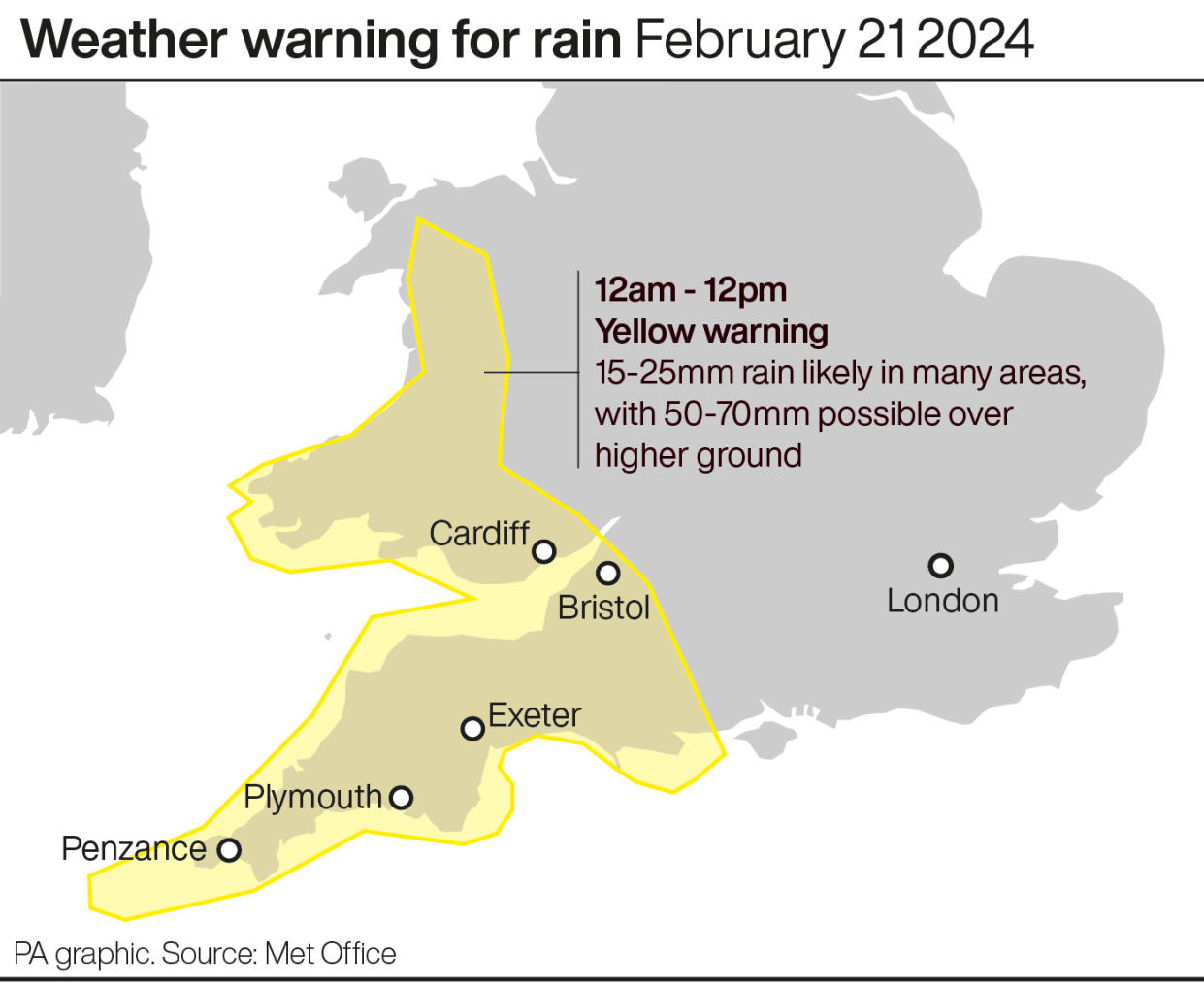
The Met Office has issued a yellow warning for rain for much of Wales and all of the south west of England between midnight and midday on Wednesday, meaning homes and businesses could be flooded.
A yellow warning also means there could be some interruption to power supplies and other services, while bus and train services may also be affected by the wet weather, leading to longer journey times.
Met Office meteorologist Alex Deakin said the rain will be a cause for concern “because the ground is saturated in places”.
He said: “That is likely to cause some issues, so there is a warning in place."
Temperatures will be mild for most of the country on Wednesday, with highs somewhere between 11C and 13C.
However, temperatures will then drop to between 7C and 10C on Thursday as wind from the north Atlantic sweeps away the rain clouds.
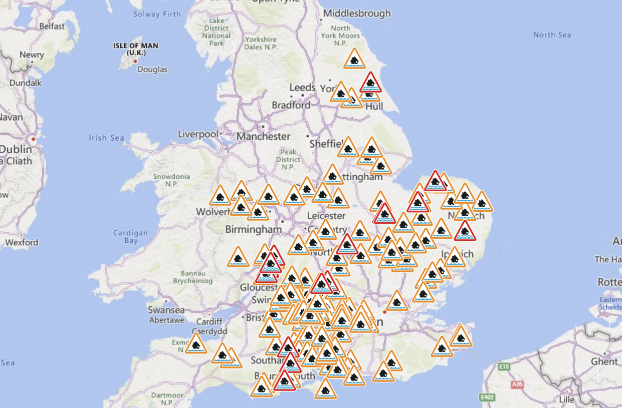
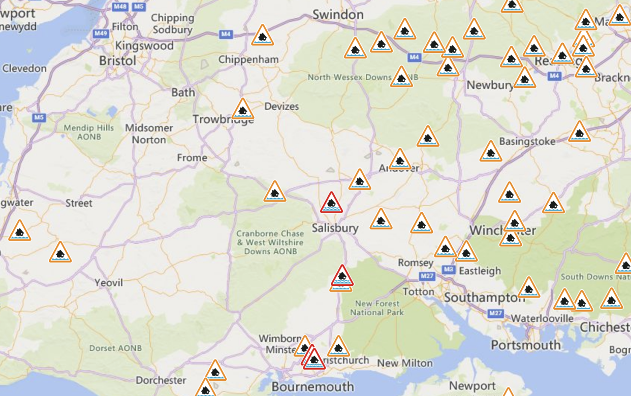
By Tuesday afternoon, the Environment Agency said there were 16 flood warnings in place in England, where flooding is "expeceted", and 142 less severe flood alerts, marking areas where flooding is "possible".
Read more: UK weather: Flood warnings in place as Britain braces for more rain and travel disruption (The Independent)
⚠️ Yellow weather warning UPDATED ⚠️
Heavy rain across parts of Wales and southwest England
Wednesday 0000 – 1200
Latest info 👉 https://t.co/QwDLMfRBfs
Stay #WeatherAware⚠️ pic.twitter.com/gpJ94QO3ll— Met Office (@metoffice) February 20, 2024
Yahoo News UK looks at what the weather will be like in your region this week, according to the Met Office forecast.
North West
Tuesday and Wednesday
More persistent rain through the day, but brighter periods developing ahead of this and turning sunnier for many to end the afternoon. Rather windy. Mild. Maximum temperature 13°C.
A wet and windy morning on Wednesday with heavy rain and coastal gales. The rain easing by lunchtime and turning much drier and brighter through the afternoon. Winds easing but staying breezy. Maximum temperature 14°C.
Thursday to Saturday
Remaining unsettled and showery throughout the period. The showers turning heavy at times, with some hill snow at times. Feeling colder than of late as temperature return to near normal.
South West
Tuesday and Wednesday
Breezy and mostly cloudy on Tuesday though a few brighter spells are possible. Some rain reaching the north of the region by around dusk. Staying mild for February. Maximum temperature 13°C.
Wet and windy on Wednesday morning with heavy rain and coastal gales. The rain easing by lunchtime and turning much drier and brighter through the afternoon. Winds easing but staying breezy. Maximum temperature 13°C.
Thursday to Saturday
Remaining unsettled with further rain or showers throughout the period. A small risk of some heavier rain and strong winds moving across the region later Saturday. Feeling colder.
Midlands
Tuesday and Wednesday
Breezy and mostly cloudy on Tuesday although a few brighter spells are possible through the middle of the day. Some rain arriving later this afternoon and staying mild for February. Maximum temperature 14°C.
Becoming wet and windy overnight with some heavy rain arriving making for a very wet end to the night.
A wet and windy Wednesday morning with periods of heavy rain. The rain will ease by lunchtime and turning much drier and brighter through the afternoon. Winds easing but staying breezy. Maximum temperature 14°C.

Thursday to Saturday
Remaining unsettled and showery throughout the period. The showers turning heavy at times, with a risk of thunder. Feeling colder than of late as temperature return to near normal.
North East
Tuesday and Wednesday
Cloud soon thickening with outbreaks of rain spreading south. These heaviest across western hills, while some eastern parts may remain dry. Cloud and rain clearing to late afternoon brighter spells. Breezy. Maximum temperature 12°C.
Wet and windy on Wednesday morning, with rain heavy at times, especially across the hills. Rain gradually clearing east, with most parts drier with sunny spells through the afternoon. Winds also easing. Maximum temperature 13°C.
Thursday to Saturday
Narrow band of blustery wind and rain clearing early Thursday. Sunny spells and isolated showers follow. Staying unsettled Friday and Saturday, with showers, perhaps longer spells of rain. Turning cooler.
London and South East
Tuesday and Wednesday
Fine, mild but rather breezy day. Occasional brighter spells possible, perhaps the odd sunny interval, but often rather cloudy. Cloud thickening further through the afternoon, with the odd spot of rain possible, mainly across the northwest. Maximum temperature 13°C.
Wet, windy morning on Wednesday, with rain, heavy at times, clearing east. Many parts drier through the afternoon, with winds easing. Chance of further rain along southern coasts, spreading inland overnight Maximum temperature 12°C.
Thursday to Saturday
Narrow band of blustery wind and rain clearing Thursday morning. Sunny spells and isolated showers follow. Staying unsettled Friday and Saturday, with further showers and sunny spells. Turning cooler.
Scotland
Tuesday and Wednesday
Dry with bright spells for most at first. Cloud soon spreads accompanied by patchy and light rain. Maximum temperature 11°C.
Overcast skies with outbreaks of rain, heavy at times on Wednesday morning. This rain becomes light and patchy by midday before clearing during the afternoon. Maximum temperature 11°C.
Thursday to Saturday
Unsettled with bright spells and showers, these merging into longer outbreaks of rain at times and falling as snow over higher ground in the west, particularly during Thursday.
Northern Ireland
Tuesday and Wednesday
Tuesday afternoon will become mainly dry with sunny spells. Maximum temperature 12°C.
Overcast on Wednesday, outbreaks of rain, persistent and heavy at times turning light and patchy by mid-morning and clearing to bright spells, showers by midday. Showers become widespread and heavy by evening. Maximum temperature 13°C.
Thursday to Saturday
Unsettled with bright spells and showers, these merging into longer outbreaks of rain at times, wintry over higher ground, particularly during Thursday.
Wales
Tuesday and Wednesday
Rain arriving from the north west through this afternoon. Another mild day but windier than on Monday. Maximum temperature 12°C.
Drier in the north this evening with clear spells. Showery rain elsewhere and this wet weather returning north overnight. Persistent and occasionally heavy rain later and becoming windy and milder. Minimum temperature 6°C.
A wet and windy Wednesday morning with heavy rain and coastal gales. The rain easing by lunchtime and turning much drier and brighter through the afternoon. Winds easing but staying breezy. Maximum temperature 13°C.
Thursday to Saturday
Remaining unsettled and showery throughout the period. The showers turning heavy at times, with a risk of thunder. Feeling colder than of late as temperature return to near normal.

