
Tropical depression may form from system off Africa; Nigel forecast to weaken
Hurricane Nigel has “likely reached its peak intensity,” National Hurricane Center forecasters said Wednesday, as attention turns to a system off Africa that is likely to become a tropical depression late this week or weekend.
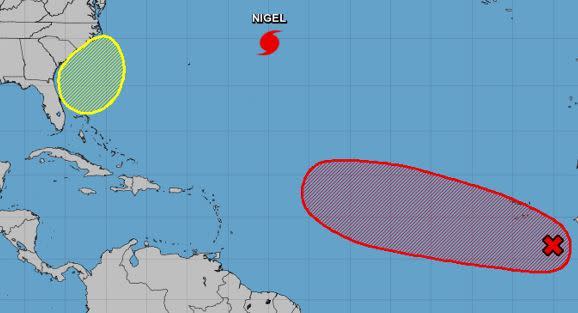
Forecasters also have their eyes on a low that may form off Florida’s east coast and cause heavy rainfall and flooding this week in South Florida before moving north.
Nigel was holding steady as a Category 2 hurricane early Wednesday with maximum sustained winds of 100 mph.
As of 5 a.m. Wednesday, Nigel was about 590 miles east-northeast of Bermuda, moving northwest at 16 mph. Hurricane-force winds extend outward up to 60 miles from Nigel’s center and tropical-storm-force winds extend outward up to 160 miles.
Swells from the storm will affect Bermuda for the next few days, causing potentially dangerous surf and rip currents.
Nigel currently poses no threat to land and could begin gradually weakening Thursday and be a post-tropical cyclone by Friday, forecasters said.
In addition to Nigel, forecasters also are monitoring a non-tropical area of low pressure that is forecast to form east of Florida late this week. Non-tropical means the mechanics of the system are more like what we’d expect in winter.
Related Articles
Storms & Hurricanes | Dirty work: How Hurricane Idalia sent 200 miles of storm surge down the west coast of Florida
As a result of the offshore low, South Florida will be increasingly stormy as the week continues, said National Weather Service meteorologist Robert Garcia on Tuesday. Once the low moves north, there could be a drying trend for the weekend.
“The big thing we’ll need to watch through the week is a chance of heavy rainfall and maybe even flooding, and strong wind gusts from the thunderstorms that could develop,” Garcia said. Flooding could occur Tuesday through Friday, he said.
The National Weather Service forecasts hazardous marine conditions off Palm Beach and Broward counties on Friday, and extending to Miami Dade County waters on Saturday. Those conditions include sustained winds of 20 to 33 knots and seas equal or greater than 7 feet. These are considered hazardous conditions for small craft.
Wind from the offshore low will be combining with remnant swells from Hurricane Lee to affect beach and ocean conditions. The National Weather Service is predicting a high risk of rip currents in Palm Beach County through Saturday, and a moderate risk in Broward County most of the week through Friday. Saturday will see high rip current risks from Palm Beach County south to Key Biscayne in Miami-Dade County.
The non-tropical low should move north toward Georgia and the Carolinas and “could acquire some subtropical characteristics this weekend while it moves generally northward,” according to the latest advisory. It has a 30% chance to develop in the next seven days as of Wednesday morning.
“Regardless of subtropical development, this low could bring gusty winds, heavy rain, and high surf conditions to portions of the coastal Carolinas into the coastal Mid-Atlantic states this weekend,” according to the latest advisory. “Gale-force northerly winds are expected off the southeastern U.S. coast Friday through Saturday,” said the National Hurricane Center.
The tropical wave that emerged off the west coast of Africa Wednesday is likely to become a tropical depression late this week or weekend and move west into the central tropical Atlantic. As of 2 a.m. Wednesday, the NHC had given it a 70% chance of developing in the next seven days while it moves west.
The NHC, which operates under the National Oceanic Atmospheric Administration, has forecast 14 to 21 named storms for the 2023 Atlantic season and six to 11 hurricanes, two to five of which would be major hurricanes.
So far this season in the Atlantic, there have been 14 named storms, six of which were hurricanes. Of those, three were major hurricanes, meaning Category 3 or above.
Those were Hurricane Lee, a rare Category 5; Hurricane Franklin, a Category 4; and Hurricane Idalia, which made landfall on Florida’s Big Bend region at Category 3 strength on Aug. 30.
The next named storm would be Ophelia.
Hurricane season officially runs through Nov. 30.

