
Met Office issues weather warnings as 'thundersnow' causes travel chaos
Many parts of Britain woke up to a wintry scene on Friday morning - with snow, ice and sleet causing travel chaos in some areas.
See also: Tourists dodge collapsing cliffs and falling trees in Madeira
See also: 'Polar vortex' could bring coldest winter for years to UK
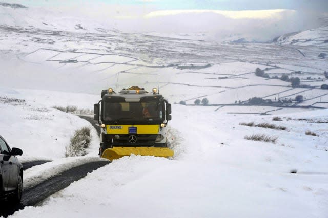
Snow hit Cumbria on Thursday, and treacherous driving conditions have been reported all the way from the Midlands to Scotland.
A car even flipped onto its roof at Snake Pass in the Peak District, and a photo of the scene was shared on Twitter.
@BBCLookNorth would not even attempt snake pass, car over turned. @snakepasswatchpic.twitter.com/NIJyqWI4JC
— Dave Maran (@DaveMaran) November 18, 2016
According to the Mirror, some areas were even hit by thundersnow, which, according to Wikipedia, is also known as a winter thunderstorm or a thunder snowstorm, an unusual kind of thunderstorm with snow falling as the primary precipitation instead of rain.
Cumbria Gritters shared an image on Twitter on Friday morning showing skid tracks on the road to warn drivers of the dangers.
Our road cam shows current conditions on A592 Kirkstone Pass. When driving in snow, leave plenty of space between you & the driver in front pic.twitter.com/BCTbkjG5OG
— CumbriaGritters (@CumbriaGritters) November 18, 2016
North News also shared images of the snow conditions in Cumbria.
It's back! ❄️❄️❄️❄️❄️❄️❄️❄️❄️❄️❄️
Pictures I've taken of snow which has been falling in parts of Cumbria this afternoon #uksnow#StormHourpic.twitter.com/TAT0A4wrJ9— PAUL KINGSTON 🌨☀️⛈✨ (@PaulKingstonNNP) November 17, 2016
Motorists have been made aware about the risk of skidding on ice, and the Met Office has issued a severe weather warning for icy conditions.
A yellow 'be aware' warning has been issued for Friday and Saturday across much of Scotland, Northern Ireland, Wales, north west England, North east England, Yorkshire, the West Midlands, and the East Midlands.
The warning reads: "A cold northwesterly airstream will continue to bring heavy showers or rain, sleet, snow and hail through this period. Clear spells in between will allow temperatures to fall close to or below freezing - hence the likelihood of some ice.
"Wintry showers, continuing during Friday and overnight, will lead to the possibility of ice forming.
"This will occur primarily on untreated surfaces but perhaps also where grit is washed off by frequent showers. Additionally, 1-3 cm of snow may accumulate on hills above around 200m and more than 5cm above 400m. Some of the heaviest showers could produce slushy conditions even at low levels. Please be aware of possible tricky travel conditions."
A yellow warning of rain and wind, of up to 65mph, has also been issued for the southern England for Sunday.
This warning reads: "A vigorous area of low pressure is expected to move northeast across southern Britain on Sunday. This will be accompanied by a period of heavy rain and southwesterly gales. Gusts of 45-55 mph could occur inland, particularly over Sussex and Kent, with gusts of 60-65 mph possible in exposed south coastal locations.
"Please be aware of the risk of difficult driving conditions due to localised surface water flooding and possible debris from trees."
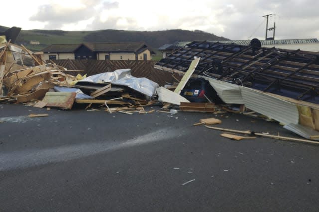
Unsettled weather swept in to the UK on Thursday.
According to the Telegraph, winds of up to 94mph hit Wales on Thursday, with a 'tornado' leaving properties damaged and felling trees.
The Metro reports that the wind "flattened caravans at an Aberystwyth holiday park" and smashed people's windows.
However, snow in Cumbria, Yorkshire and Glencoe brought some pretty scenes and picture opportunities.
#Snow melting fast this morning @KeswickTourism@CumbriaWeather@BBC_Cumbriapic.twitter.com/8m4OF61Udc
— Castlerigg Hall (@CastleriggHall) November 18, 2016
Looking at the weather over the weekend and into early next week, the Met Office said of Saturday: "Another cold start. Some showers in the north, west and far south, but many places dry and sunny, although cold. Wind and rain arrives in the south-west during evening."
And the forecast for Sunday to Tuesday reads: "Strong winds and heavy rain will affect England and Wales at times through this period. Scotland and Northern Ireland generally drier, although still breezy at times with showers."


