
Heavy snow could hamper early arrival of spring
Nature experts say spring is already on the way - but that heavy snow could now "halt its march".
Early signs of spring have been spotted after the warmest year on record for the UK.
Sightings of snowdrops, hazel catkins and even ladybirds and butterflies have been submitted to the Woodland Trust's Nature's Calendar scheme, which asks the public to report natural events which mark the changing seasons.
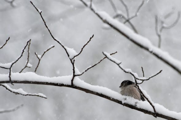
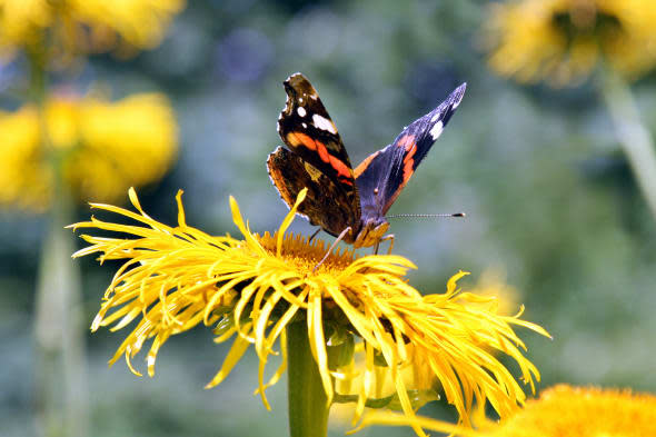
So far in 2015, there have been reports of snowdrops at 120 locations across the country, hazel catkins at 74 spots and even sightings of ladybirds, small tortoiseshell, peacock and red admiral butterflies, the Woodland Trust said.

In November, the Trust received a record of frogspawn on the Lizard Peninsula in Cornwall, the earliest such incidence for nine years.
A warming climate has seen spring coming earlier, and three of the last four years have seen some of the earliest spring averages the Trust has compiled from its monitoring of the seasons in Nature's Calendar for the last 15 years.
Research looking at nature records stretching back to the 18th century has found flowers over the last 25 years blooming up to 12 days earlier than previously.
The current freezing conditions may halt the march of spring, but conservationists say that causes less of a problem than a late cold snap, as happened in 2013, when more species are likely to be awake from hibernation or already flowering.
Dr Kate Lewthwaite, Woodland Trust citizen science manager, told the Press Association: "People still seem to be surprised to see snowdrops and butterflies in early January, but our warmer climate in recent years means this is now pretty common.
"Records added to Nature's Calendar by the public have enabled scientists to learn how trees, plants and wildlife adapt to our changing climate.
"If we can ensure our natural environment is diverse, resilient and interconnected it will make it easier for wildlife to adjust too."
The Trust said it would be working in partnership with the British Science Association to estimate the rate spring progresses this year.
National Trust's national specialist on nature and wildlife, Matthew Oates, said: "Spring has been calling for some time, due to a mild autumn, December and early January. The signs are all around us.
"Hazel catkins were quite prominent in southern England before Christmas and are now well in flower, such that some hay fever suffers - like me - are already experiencing symptoms."
He added: "Spring's advance has now been checked by the arrival of the first cold snap since March 2013. Perhaps spring needed slowing down, as early springs are risky and almost always end in tears."
But he urged the public to look out for the signs of spring and report them to the Woodland Trust's Nature's Calendar.
So, weather-wise, what does this week have in store exactly? Leon Brown, meterologist at The Weather Channel, told Aol Travel: "After a few days of mild weather another seven days of colder weather will arrive during Wednesday. There will be quite a drop in temperature during the day behind a cold front on Wednesday.
"Between this Wednesday and next Wednesday, snow will be in the forecast for just about everywhere, but amounts will vary quite a bit, even locally.
"The weather pattern from Wednesday will be very similar to two weeks ago with a very unstable polar maritime air mass dragged all the way from North West Canada.
"There'll be a lot of showers over the west on Wednesday night to Thursday, turning readily to snow inland and some thunder around coasts.
"There'll be some moderate to heavy snowfalls on Wednesday night to Thursday over West Scotland, Northern Ireland to North West England, and snow showers also moving over the higher parts of the south west on Thursday morning with 5cm to 10cm across Exmoor and the Mendips. Mid and North Wales may also catch 5cm to 10cm.
"The main snow risk areas on Thursday night to Friday look like Wales again with another 5cm to 10cm, and more over the higher mountains. Some snow showers moving over the western Midlands towards the London area may give 2cm to 4cm.
"Later on Friday and Friday night it will be the turn for North England and then East Anglia to see some snow as an occluded front moves south.
"By next weekend the UK will be in a northerly Arctic flow with hail, sleet and snow showers around coasts and over northern Scotland, with just a few showers inland over southern Britain.
"Before the cold snap is pushed away, it looks like there will be another snow risk next Monday as an area of low pressure tracks southwards in the Arctic flow. This may bring 5cm to 10cm quite widely over northern Britain, and a lot more over the higher hills in Scotland and Pennines. As much as 5cm also is likely as far south as the Midlands.
"The lowest temperatures in this cold snap look likely on Sunday when winds will drop out for a time. We could see -8C to -10C over parts of the north on Sunday morning."
Love spring? Spot the signs:

Need to escape the wintry weather? We've got just the thing:

Related articles
UK weather: Four inches of snow to fall this week
Police remind residents that they live in Norway after snow complaints
Fisherman tweets terrifying picture of huge wave in North Sea


