
UK weather: 'Storm Charlie' to bring a month's rain in less than a week
There will be no let-up in the floods and storms that have battered Britain's south west coast over the last few days - with forecaster predicting a whole month's worth of rain to fall in less than a week as a new storm, called 'Charlie', hits the UK.
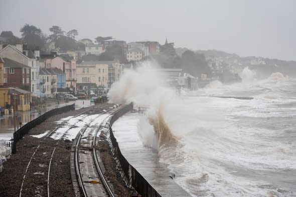
Gales, torrential rain and storms have left thousands without power, as well as destroying the railway track in Dawlish that connects Devon and Cornwall to the rest of the UK. Intense waves battered the line, causing it to collapse. A destruction that, according to the BBC, Network Rail believes will take a minimum of six weeks to repair.
And forecasters are warning of more to come, with "structural damage-threatening" 80mph winds and torrential rains hitting.
Meteorologist at The Weather Channel, Leon Brown, told Aol Travel: "With the jet stream set to remain in its current track across the mid Atlantic, there will be no let-up in the wet and sometimes stormy weather through most of February.
"In the next two weeks the southern portion of the UK from Cornwall and Devon, south Wales to Essex and Suffolk can expect 200 to 300% of normal precipitation, or two to three times as much as normal.
"Some places in the south west will probably receiving a month's worth in the next five days.
"The next band of heavy rain will sweep eastwards on Friday night and clear the east coast before dawn. This will bring another 20mm to 25mm over West Wales and 20mm to 20mm over southern counties by Saturday morning. At the same time southerly gales developing along the south coast, so many areas receiving a similar battering from the sea as on Wednesday.
"We are calling this storm 'Charlie'.
"During Saturday a deep area of low pressure will move across Ireland to Scotland with squally and wintry showers sweeping around the southern side across Wales and western England.
"Gales around all coasts and severe gales around Cornwall, Devon, and up to West Wales and Somerset. We can expect 80mph gusts again over exposed coasts in the south west, and inland across much of central and southern Britain 60mph gusts are likely, which will threaten some structural damage.
"Scotland and the north of England miss the worst of the winds, but showers will fall as snow over the Pennines and Scottish Mountains."
He adds that winds will create monster 15 metre waves on the coast, saying: "With storm force 10 winds expected for 24 hours to the south of Ireland, huge seas will again approach south west Britain on Saturday. Significant wave heights will approach 15m off Cornwall and will then run up towards south west Wales and also to the west Channel."
Leon adds the the winds will only gradually die down on Sunday with further heavy showers in the morning, especially near southern coasts as showers run east along the Channel.
And the outlook for next week is not much brighter. Leon says: "There will be more severe weather next week – thankfully Monday will be quieter but a band of rain moving east early on Tuesday will bring snow to northern Britain and higher ground in Wales with more than 10cm possible.
"The next storm may run further south along the Channel on Wednesday and could be very deep and ferocious, impacting Northern France as well as the UK – but this is something we will track.
"Potential for severe gales and 25-50mm of rainfall across Britain, plus heavy snow for northern Britain."
Time to plan that winter escape? Try one of these getaways:

Related articles
Heavy rain creates 5ft deep gullies in Devon
Extreme 'polar plunge' hits the US

