
'Tornadoes' appearing across Britain ahead of thunderstorms (pictures)
Ahead of reports of the worst hail storms in 170 years set to hit Britain at the weekend, tornado-like clouds have been appearing across the UK.
The Met Office has warned unusually severe weather is expected to batter Britain starting on Friday.
Forecasting models predict a huge plume of warm air will sweep into the UK from the continent triggering the extreme weather.
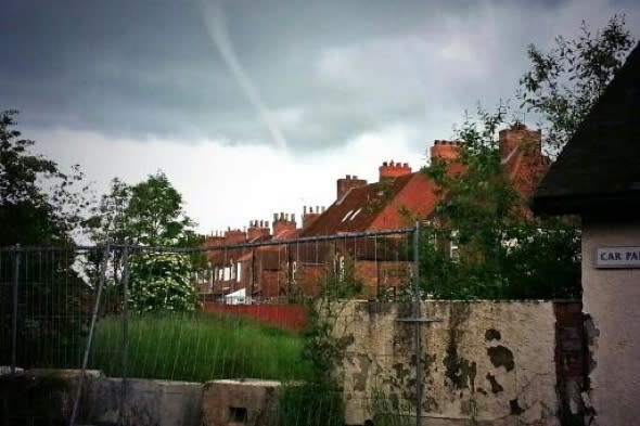
But across Lincolnshire on Wednesday, extreme weather conditions appeared to be already forming with multiple sightings of tornado-like cloud formations.
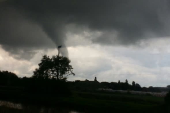
Geoff Hill, 54, managing director of Rase Distribution, works at the Wickenby Aerodrome, near Market Rasen, Lincs, spotted the cloud formations at around 3pm.
He told Caters News: "It was spotted by one of our store staff working outside looking up at the sky. Somebody rushed in and said there's a tornado.
"So we went outside and I grabbed my camera and took a picture. I actually caught it on the second go because it had formed for five minutes before and then disappeared.
"Then it formed again and appeared for another five minutes."
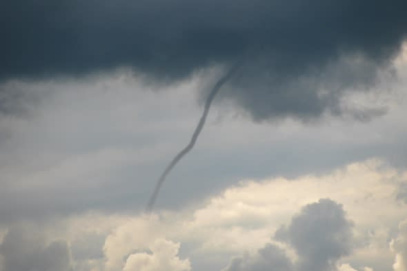
Elsewhere in the county, photographer Stu Morant also caught amazing images on camera near Crowle, near Scunthorpe, North Lincs, around 4.30pm.
According to Leon Brown, meteorologist at The Weather Channel, a cold front will begin to move eastwards on Friday night, and ahead of the front some heavy showers with the risk of hail and thunder are likely to develop.
He told Aol Travel: "In the early hours of Saturday these will move across south west England to Wales, and by dawn over the Midlands. The thundery downpours then moving to eastern and northern England in the afternoon, and up to south west Scotland and the north east of Ireland too. Brighter and clearer weather will follow to Wales and southern England in the afternoon.
"There is a risk on Saturday evening that a few more thunderstorms could track across the south east of England from France. The risk is mainly for Kent and East Sussex. Temperatures will be 17C to 19C in the west and 22C to 25C over the east of England. Up to 23C in northern Scotland.
"At the moment the highest rainfall totals look like they will be in the morning on Saturday over East wales to the West Midlands with up to 30mm locally, but typically 15 to 20mm, so local flooding is likely for a time and a lot of water in the downpours on roads.
"In the afternoon, north west England to south west Scotland can expect 15mm to locally more than 20mm. The risk of small hail up to 1cm in the heaviest downpours too. There is a slight risk of larger hail up to 2.5cm. There may be some locally strong gusts of wind around some of the storms, but otherwise winds will be fairly light."
There's better news for Sunday, Leon added: "A much improved day for Sunday with plenty of sunshine in the south and east. There will be a few showers over Wales, central Scotland and Ireland. Temperatures will be in the low 20s in the sunshine over central to eastern England."
"Early next week will remain quite unstable with the threat of some thundery downpours on Monday over the south and east of England."
But then it's good news for the end of next week, with the possible arrival of 'summer'. Leon said: "High pressure will build and temperatures will rise again later next week. The end of next week may become very warm with temperature in the mid to upper 20s Celsius and feeling like summer has arrived."
Related articles
Tornado caught on camera in Cambridgeshire
Mini tornado caught on camera in UK pub car park


