
Storm Abigail: Met Office upgrades weather warning over 90mph winds
Storm Abigail is set to wreak havoc in some parts of the UK from Thursday - with lightning, heavy rain and severe gales of up to 90mph,
The Met Office has upgraded its weather warning from a yellow 'be aware' level to an amber 'be prepared' warning for Orkney and Shetland and the Scottish Highlands for Thursday and Friday.
See also: Storm Abigail to bring blizzards and severe gales
See also: Will it be a White Christmas 2015?
Referring to these areas, its website says: "Southwesterly severe gales will develop later on Thursday, increasing storm force for a time as they veer westerly overnight into early Friday.
"Gusts of 70 to 80 mph are likely, and perhaps 90 mph across exposed locations. Winds will begin to ease and veer more westerly across the Western Isles and the mainland on Friday morning and across the Northern Isles on Friday afternoon.
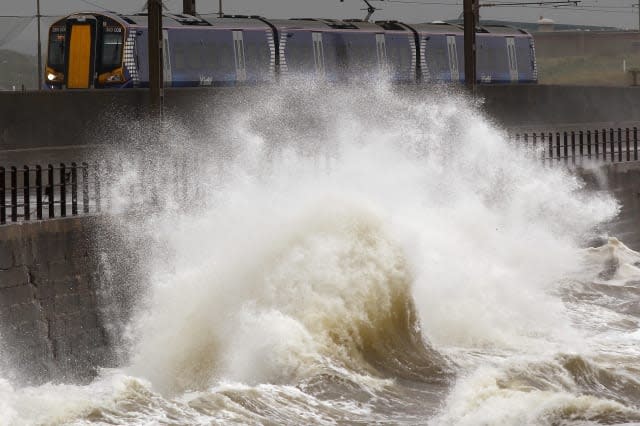
"Lightning associated with frequent showers will be an additional hazard, whilst large waves may lead to over-topping along some coasts and causeways.
See aol weather for your local forecast.
"The public should be prepared for disruption to transport and perhaps power supplies."
The yellow 'be aware' warning is still in place for Thursday and Friday for large parts of Scotland.
Richard Chapman, spokesman at The Weather Network, also talked of severe gales and "the risk of minor damage to buildings". In a detailed breakdown of the forecast, he told Aol Travel: "Storm Abigail will bring severe gales to the west and northwest of Britain and Ireland later on Thursday, gusts likely over 70mph, locally 80 mph to 90mph around the Western Isles and over Scottish mountains. This is likely to disrupt transport, particularly ferries and bridge crossings.
"Rain will also sweep into western Britain, turning heavy later on Thursday over western hills, spreading to most northern regions through the evening. It will stay mild on Thursday, with highs from 11C to 15C.
"Much colder air will follow behind a cold front overnight into Friday, bringing a much colder feeling day compared to recent times. Temperatures will range from 8C in the north, to 11C in the south.
"Frequent heavy and squally showers will affect the country throughout Friday. These will fall as snow above 600m to 800m on the Scottish mountains, and highest mountains in the Lake District.
"Hail will fall to low levels, and also expect thunder and lightning during heavier showers. The most frequent bursts will affect the north-west, merging into longer bouts of rain. It will be brighter toward the east, with some bright sunshine at times away from showers.
"Winds will also remain strong and gusty, continuing severe gales across Scotland early in the day may cause further disruption to travel and risk of minor damage to buildings, with gusts to 70mph.
"Into the weekend, and the remnants of Hurricane Kate should keep things unsettled, with another batch of heavy rain due to move in from the west on Saturday. This may give prolonged falls over north-west England and Wales, leading to possible flooding. Around 30mm to 50mm may fall by the end of the day in lowland western England and Wales, but there's a risk of 70mm to 100mm over the hills in the Lake District and Snowdonia.
"Southern Britain should escape the worst of the rain, and will be a little milder than Friday at 13 to 15C, whilst Scotland stays cool at 10C.
"Winds will be strong, with a threat of gale force gusts across central Britain, perhaps 50mph to 60mph even well inland, but this will need monitoring closely.
"Sunday will bring another heavy fall of rain to Cumbria, and also western Scotland, where further flooding issues may develop. Gales again threaten the north-west.
"Next week will stay unsettled, with frequent wind and rain spreading from the Atlantic. It will be cooler than recently, with snow occasionally on the Scottish mountains, although unlikely at low levels. Temperatures are likely to range between 7C and 13C from north to south."


